

Laser scanning vs traditional measurement comes down to coverage versus simplicity. A scanner records millions of 3D points in minutes, typically within a few millimeters. Traditional tools such as tapes, levels and total stations capture fewer points, yet they can match that accuracy on single dimensions. Choose by the job, not the hype.
Convert Scan Tolerances Between Millimeters and Inches
Scanner and survey specifications are usually in millimeters, while many US drawings use inches. Enter a tolerance or distance below to compare them using the exact definition of the inch.
Engineers rarely pick a method by habit alone. Instead, they weigh how many points they need, how accurate each one must be, and how much time the site allows. As a result, the same team may scan a plant room in the morning and check one pipe flange with a caliper in the afternoon.
This guide explains laser scanning vs traditional measurement in plain terms. First, it shows how each method works. Next, it compares accuracy, speed and cost with numbers from published sources. Finally, it gives a short process for choosing the right tool.
One caution before we start. Vendors often quote best-case figures, and research papers test limited setups. For that reason, treat any single number as a typical value, not a promise. A study reported on the ACSR site, for example, found that a scanner and a total station agreed within 0.8 mm on average across 20 distances, with a standard deviation of 2 mm and a largest difference of 6 mm.
Key Takeaways
- A scanner wins on coverage: millions of points from one setup.
- A total station or tape wins on simplicity for a few key dimensions.
- Both can reach millimeter-level results when used well.
- Scanning needs processing time, software and registration of overlapping scans.
- Reflective, dark and wet surfaces can degrade laser returns.
- Always cross-check a few known distances with a second tool.
Laser Scanning vs Traditional Measurement at a Glance
This table compares the two approaches on the points that matter most. Values are typical, so check the specification of your own instrument.
| Factor | Laser scanning | Traditional methods |
|---|---|---|
| Data collected | Millions of points (a point cloud) | Chosen points and dimensions |
| Typical accuracy | About 3 to 6 mm at 50 to 100 m in published specs | About 1 to 2 mm for a total station point; tapes and calipers vary with the tool |
| Field speed | Minutes per setup | Seconds per point, but many points take time |
| Office work | Registration, cleaning and modeling | Plotting or entering a short list of values |
| Skill needed | Scanner and software training | Basic for tapes; more for total stations |
| Best for | Complex, crowded or hard-to-reach sites; as-built records | Layout, spot checks, small parts and simple spaces |
How Laser Scanning Works
A terrestrial laser scanner sweeps a beam across its surroundings and measures the distance to each spot. The result is a point cloud, a set of coordinates that describes the shape of everything the beam touched. According to the University of Arkansas CAST, these scanners measure distance from a precise measurement of time, and they use one of two main approaches.
- Time of flight. The scanner sends a short pulse and times its return.
- Phase shift. The scanner sends a continuous beam and compares the phase of the outgoing and returning light.
The timing is extremely fine. Light travels at exactly 299,792,458 m/s, so a 3 mm distance step needs timing resolution near 20 picoseconds for a round trip. In practice, instrument makers solve this with specialized electronics and by averaging many pulses.
An older overview from the scanner maker Zoller+Frohlich, published in the ISPRS proceedings, lists pulsed scanners with ranges up to several hundred meters and accuracy under 10 mm within 100 m. It also lists phase-based scanners with a range of about 100 m and accuracy of a few millimeters. Newer models are better, but the trade-off between range and precision remains.
How Traditional Measurement Methods Work
Traditional methods measure chosen points or dimensions one at a time. Tapes, rulers and calipers measure directly against a scale. Levels check whether a surface is flat or plumb. Total stations combine an angle sensor with a distance meter to locate points in space.
Specifications show how capable these tools are. A Leica TS13 datasheet lists angle accuracy of 1 to 5 arc seconds depending on the model. It also lists distance accuracy of 1 mm plus 1 ppm with a prism and 2 mm plus 2 ppm without one. Our guide on how to use a total station explains the setup step by step.
For small parts and quick checks, simple tools still do the job. A good tape, a level and a caliper cost little and need no software. Moreover, you can verify them in seconds against a known length. For more on tapes, see the construction tape guide.
Laser Scanning vs Traditional Accuracy
Accuracy is where the old claim “scanning is always better” breaks down. A scanner’s accuracy depends on range, surface and angle, whereas a total station point can be very tight at a modest distance. The ISPRS overview states that scanner distance accuracy depends mainly on the intensity of the reflected light, which in turn depends on the angle and the surface.
A total station’s angle error also grows with distance. Using the exact geometry, a 1 arc second error moves a point by about 0.24 mm at 50 m and 0.48 mm at 100 m. A 5 arc second error moves it by about 1.2 mm at 50 m and 2.4 mm at 100 m.
| Item | Value | Inches |
|---|---|---|
| Total station 1 arc second at 50 m | 0.24 mm | 0.0095 in |
| Total station 1 arc second at 100 m | 0.48 mm | 0.019 in |
| Total station 5 arc seconds at 100 m | 2.4 mm | 0.095 in |
| Scanner accuracy in a published older spec at 50 m | 6 mm | 0.24 in |
In short, both methods work at the millimeter level, so the real difference is how the error behaves. A scanner spreads many small errors over a whole surface. A total station concentrates its quality in the points you choose.
Laser Scanning vs Traditional Speed and Workflow
Speed depends on what you count. In the field, a scanner is very fast: a phase-based unit in the ISPRS overview records about 500,000 points per second. By comparison, a total station shot takes about 2 seconds in reflectorless mode according to the Leica datasheet, which is at most 1,800 points per hour even without stops.
The office side tells the other half of the story. Scans must be registered, which means aligning separate setups into one model. External references such as spheres or checkerboard targets help with a reliable alignment, as the ACSR study notes. Then the data must be cleaned and turned into a model or drawing.
Therefore, laser scanning pays off when you need a lot of data. If you only need ten dimensions, a tape and an hour will usually beat a scanner and a day of processing.
Laser Scanning vs Traditional Cost
Scanning costs more up front. You pay for the instrument, the software, a capable computer and training. Traditional tools, in contrast, range from very cheap (tapes, levels, calipers) to moderate (total stations). Because prices change quickly, check current listings instead of relying on a number in an article.
Cost also includes time and risk. A scan can reduce return trips, because you capture the whole site once and measure later on screen. On the other hand, a missed area means going back with the scanner. For simple jobs, therefore, the lower cost of traditional methods usually wins.
Where Laser Scanning vs Traditional Methods Fit in Engineering
Scanning suits industrial plants, bridges, tunnels, building interiors and heritage sites, where geometry is complex and access is limited. The University of Arkansas page, for example, lists architectural documentation, geological profiles, archaeology and infrastructure monitoring among its uses.
Traditional methods suit layout, setting out, small assemblies and routine checks. A caliper is the right tool for a shaft diameter, and a level is the right tool for a slab. Likewise, a laser distance meter is a simple middle path for room dimensions. We compare models in our floor plan laser measurer guide.
How to Choose Between Laser Scanning vs Traditional Methods
- Define the deliverable. Decide whether you need a few dimensions, a drawing or a full 3D model. This single choice rules out half the options.
- Write down the tolerance. State the accuracy you need in millimeters or inches. Rough layout may accept 10 mm, while fitting parts may need 1 mm or less.
- Check access and line of sight. Walk the site. Scanners and total stations both need clear views, so note obstacles, reflective surfaces and tight spaces.
- Estimate the number of points. If you need a handful of dimensions, use a tape, caliper or total station. If you need thousands, consider a scanner.
- Weigh the full workflow. Add field time, processing time and software. A fast scan can still need hours at a computer.
- Plan a cross-check. Measure two or three known distances with a second tool, so you can confirm the result.
- Choose, then document. Record the method, instrument, date and conditions with the data, so others can judge the result later.
Recommended Tools for Accurate Distance and Dimension Checks
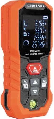
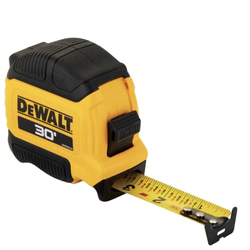
You do not need a scanner to improve your measurements. A reliable laser distance meter, a caliper, a long tape and a good level cover most day-to-day engineering checks. In addition, they work well as cross-checks for scan data.




As an Amazon Associate, Measuring Expert earns from qualifying purchases.
Laser Scanning vs Traditional Pros and Cons
Laser scanning
- Pro: captures every visible surface in one visit.
- Pro: lets you measure later on screen.
- Pro: reaches places that are hard or unsafe to access.
- Con: needs software, training and processing time.
- Con: struggles with shiny, dark or transparent surfaces.
Traditional methods
- Pro: low cost and quick to start.
- Pro: easy to check and understand.
- Pro: excellent for single points and small parts.
- Con: slow when you need many points.
- Con: records only what you chose to measure.
Do and Don’t When Choosing a Method
Do
- State the tolerance before you pick a tool.
- Cross-check scan data with a known distance.
- Record the instrument and conditions.
- Plan for processing time.
- Use targets for overlapping scans.
Don’t
- Assume a scan is exact because it is digital.
- Scan a simple job that a tape can finish.
- Ignore reflective or wet surfaces.
- Skip the calibration or check of your tools.
- Compare accuracy numbers from different test setups as if they were equal.
Honest Limits of These Comparisons
Published accuracy numbers come from different tests, ranges and surfaces, so they are not directly comparable. The ISPRS overview itself notes that scanners lacked common accuracy specifications at the time. In addition, the ACSR comparison used only 20 distances in one scene, so it is a useful hint rather than a rule.
Instrument specs also describe ideal conditions. Weather, dust, vibration and temperature can all shift results. As a result, the safest approach is to test your own setup against a known reference before the job starts.
When to Call a Professional
Call a licensed surveyor or a scanning service when the result must be certified, tied to property boundaries, or used for permits and legal records. Likewise, hire one when the site is large, hazardous or complex.
Frequently Asked Questions
What is the difference between a survey and a laser scan?
A traditional survey measures chosen points, often with a total station. A laser scan records millions of points across every visible surface. The scan gives more coverage, while the survey is simpler to check.
What are the cons of laser scanning?
The main cons are higher equipment and software cost, large files, line-of-sight limits and the need to register scans together. Shiny, dark or wet surfaces can also give poor returns.
How accurate is laser scanning vs traditional measurement?
Published scanner specifications run from about 3 to 6 mm at 50 to 100 m. A total station can reach about 1 to 2 mm on a single point, so the best method depends on the task.
Is laser scanning vs traditional measurement a question of accuracy or coverage?
Mostly coverage. Both can reach millimeter-level results. A scanner captures everything it can see, while traditional tools capture only the points you choose.
What is the difference between structured light scanning and laser scanning?
Structured light projects a known pattern and reads how it bends, which suits small objects at close range. Laser scanning measures distance with a beam, which suits rooms, plants and sites.
Does laser scanning replace tape measures and levels?
No. Crews still use tapes, levels and calipers for quick checks and small parts. A scan is most useful when you need a full record or many dimensions at once.
Can a laser scan be wrong?
Yes. Reflective, dark or transparent surfaces, steep angles of incidence and poor scan registration can all add error. Checking a few known distances with a tape catches most problems.
How long does a laser scan take?
One setup often takes a few minutes, and a building may need many setups. A total station shot takes a few seconds, but you need one for each point.
Laser scanning vs traditional: which is cheaper for a small job?
Traditional tools usually win on small jobs. A tape, level or caliper costs far less than a scanner and needs almost no training.
When should I hire a surveyor or scanning service?
Hire one when the result must be certified, tied to property lines or used for permits, or when the site is large, complex or unsafe to reach.
Laser Scanning vs Traditional Methods: The Bottom Line
To sum up, a scanner gives you coverage and a permanent record, while traditional tools give you simplicity and low cost. Both can reach millimeter-level results, so decide by the number of points, the tolerance and the site.
Finally, whichever method you choose, check a few known distances with a second tool. That small habit catches most errors before they reach the drawing.