

To measure slope and gradient for construction sites, you need accurate tools and methods. This ensures safety and proper design implementation.
Understanding how to measure slope and gradient is crucial in construction. It affects drainage, stability, and structure safety. A small miscalculation can lead to costly mistakes or even accidents. In this guide, we will explore the essential tools and techniques for measuring slopes and gradients.
You will learn how to achieve precision in your measurements. Accurate slope and gradient measurements can make a significant difference in your construction projects. So, let’s dive into the details and ensure your next project is on solid ground.
Introduction To Slope And Gradient
Slope and gradient are crucial in construction. They impact safety and design. Understanding them helps in planning and building. Both terms relate to the steepness or incline of a surface.
Importance In Construction
Slope and gradient affect water drainage. Proper drainage prevents water damage. They also impact the stability of structures. A wrong slope can lead to landslides or foundation issues.
They are key in designing roads and pathways. Proper gradient ensures vehicles and pedestrians move safely. Builders must consider these factors to meet safety standards.
Basic Concepts
Slope is the measure of steepness. It is calculated as the rise over the run. The rise is the vertical distance. The run is the horizontal distance.
Gradient is often expressed as a percentage. It shows the incline over a given distance. For example, a 5% gradient means a 5-meter rise over 100 meters.
Understanding these terms helps in creating accurate site plans. It ensures buildings and infrastructure are safe and functional.
Tools For Measuring Slope
Hey there, friends! Today, we’re diving into the world of measuring slopes and gradients on construction sites. This is super important for making sure everything is built right and safe. To get accurate measurements, you need the right tools. In this section, we’ll explore both traditional tools and modern instruments that make this job easier. Let’s get started!
Traditional Tools
First, let’s talk about the traditional tools. These are the tried-and-true methods that have been around for a long time. They may not be fancy, but they get the job done.
- Spirit Level: This is a simple tool with a bubble inside a liquid-filled tube. It helps you check if a surface is level or not. It’s easy to use and very handy on site.
- Measuring Tape: You can use a measuring tape to measure distances and calculate the slope. It’s straightforward – just measure the rise and run, then divide them.
- Plumb Bob: This is a weight with a pointed tip at the bottom, hung from a string. It helps you find the vertical line, which is essential for measuring slopes accurately.
These tools are reliable and you can find them on almost any construction site. But they do require some manual effort and experience to get accurate results.
Modern Instruments
Now, let’s check out the modern instruments. These tools use advanced technology to make measuring slopes faster and more precise. They are great if you want to save time and reduce the risk of errors.
- Digital Inclinometer: This device measures angles electronically. You just place it on the surface, and it shows the slope angle on a digital display. Easy peasy!
- Laser Level: A laser level projects a straight line that you can use as a reference. It’s very accurate and helps you measure long distances without any hassle.
- Total Station: This is a more advanced tool used by surveyors. It combines an electronic theodolite with a distance meter. It can measure both angles and distances, making it perfect for large construction sites.
Modern instruments are a bit more expensive than traditional tools, but they offer great accuracy and efficiency. If you’re working on a big project, investing in these tools can save you a lot of time and effort.
So, whether you’re using old-school tools or the latest gadgets, measuring slopes and gradients is a crucial part of any construction project. It ensures everything is built correctly and safely. Happy measuring!
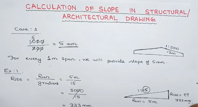
Calculating Slope Manually
Measuring slope and gradient for construction sites involves simple steps. First, measure the rise and run. Then, divide the rise by the run to find the slope. This helps in planning and ensuring safety on construction sites.
Hey friends, today we’re diving into a crucial topic for anyone involved in construction: measuring slope and gradient. Understanding slope is essential for ensuring your construction site is stable and safe. Let’s break it down into simple steps.Rise Over Run Method
Using A Clinometer
Credit: www.quantity-takeoff.com
Using Digital Tools
Using digital tools to measure slope and gradient is becoming more common in construction. These tools provide accurate data and save time. They are also easy to use, even for beginners. In this section, we will explore some of the most popular digital tools.
Slope Calculation Apps
Slope calculation apps are useful. You can download them on smartphones or tablets. These apps use the device’s sensors to measure the slope. They provide quick and accurate readings. Many apps also offer additional features. For example, some can store data for future use. Others can generate reports. This makes them convenient for construction sites.
Laser Levels And Gps
Laser levels and GPS devices are essential for measuring slope and gradient. Laser levels project a straight line. This helps in determining the slope accurately. They are very precise and easy to use. GPS devices are also handy. They provide real-time data on the slope. You can use them to map out large areas. This is especially useful for big construction projects.
Both laser levels and GPS devices improve efficiency. They reduce the margin of error. This ensures better planning and execution. Investing in these tools can save time and reduce costs in the long run.
Field Survey Techniques
Measuring slope and gradient on construction sites is crucial for accurate planning and safety. Field survey techniques play an essential role in this process. These techniques help gather precise data about the land. This section will explore two effective methods used in field surveys: topographic surveys and using drones.
Topographic Surveys
Topographic surveys provide detailed information about the land’s surface. Surveyors use specialized equipment to measure the terrain. This includes levels, theodolites, and total stations. The data collected helps create a detailed map. This map shows the site’s elevations, slopes, and natural features. Contractors use these maps for design and construction planning. Accurate topographic surveys ensure the project aligns with the natural landscape.
Using Drones
Drones are becoming popular in construction surveys. They offer a quick and efficient way to measure slopes and gradients. Equipped with cameras and sensors, drones capture high-resolution images. These images are then processed to create 3D models of the terrain. Drones can cover large areas in a short time. This reduces the need for extensive ground surveys. The data gathered is precise and helps in planning and executing construction projects.

Credit: www.youtube.com
Interpreting Slope Data
Hey there! Today, let’s dive into a crucial topic for anyone involved in construction—interpreting slope data. Understanding slope and gradient is vital for safe and efficient construction sites. So, how do we make sense of those numbers? Let’s break it down together.
Understanding Results
Once you’ve gathered your slope data, the next step is to interpret what it means. Think of it like reading a recipe. You have all the ingredients, but you need to know how to put them together to make a delicious dish. In construction, the data helps you understand the lay of the land.
Here’s how to make sense of it:
- Slope Percentage: This tells you how steep the land is. A 10% slope means the land rises 10 units for every 100 units horizontally.
- Gradient Ratio: This is another way to express slope, like 1:10. It means the same thing—a rise of 1 unit for every 10 units horizontally.
Understanding these results helps you plan. It tells you where you might need to cut into the land or build up areas to create a level foundation.
Common Mistakes
Interpreting slope data can be tricky, and mistakes are common. But don’t worry, we’re here to help you avoid them:
- Ignoring Small Details: Every little detail matters. Missing a small slope can lead to big problems later.
- Overlooking the Big Picture: Focus on the entire site, not just one area. The slope in one spot can affect the whole project.
- Misreading Data: Double-check your measurements. A small error can throw off your entire plan.
I’ve seen projects where a tiny mistake in slope interpretation led to drainage issues. And trust me, fixing that later is a headache you don’t want.
So, there you have it! Interpreting slope data is like putting together a puzzle. Each piece of data fits together to give you a clear picture of your construction site. Keep an eye on the details, understand your results, and avoid common mistakes. Happy building!
Slope And Gradient In Design
Learn to measure slope and gradient for construction sites. Use tools like a level, measuring tape, and calculator. Ensure accurate measurements for a safe and stable build.
Understanding slope and gradient in design is crucial for construction projects. Slope refers to the steepness or incline of a surface. Gradient is the measure of change in elevation over distance. Both affect the stability and safety of structures. Accurate measurements ensure proper drainage, prevent erosion, and support structural integrity.Impact On Structures
The slope directly impacts the stability of structures. A steep slope can lead to soil erosion. This affects the foundation and durability of buildings. Proper gradient management ensures that water flows away from structures. This prevents water damage and maintains the integrity of the construction.Safety Considerations
Safety is paramount in construction. Incorrect slope measurements can lead to accidents. Slippery surfaces or unstable ground pose risks. Proper gradient ensures safe and accessible paths. This reduces the risk of slips, trips, and falls. Accurate slope and gradient measurements protect workers and future users. “`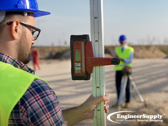
Credit: www.engineersupply.com
Case Studies
Hey friends, today we’re diving into an exciting topic – Case Studies on how to measure slope and gradient for construction sites. Understanding these principles is crucial. Why? Because it ensures safety and efficiency. Let’s explore some real-world examples, shall we?
Successful Projects
Let’s start with some success stories. These projects nailed the slope and gradient measurements. They saw great results.
One standout example is the new park in downtown. This park’s construction team used precise gradient measurements. The result? Smooth walking paths and safe playgrounds. They achieved this by:
- Using advanced measuring tools
- Regularly checking slope stability
- Adjusting plans based on real-time data
Another project is the residential complex on Hillside Avenue. The team faced a steep terrain. But with accurate slope measurements, they created stable foundations. This ensured the houses were safe and durable.
Lessons Learned
Now, let’s talk about lessons learned. These are just as important as success stories. They help us improve.
Take the highway expansion project. The team initially ignored minor slope variations. What happened? After a heavy rain, parts of the road became unstable. They learned the hard way. Small slope changes matter.
Another example is the coastal resort project. They underestimated the gradient impact on drainage. Result? Waterlogged grounds. They had to redo the drainage system. Their lesson? Always consider gradient in water flow planning.
In summary, these case studies show the importance of accurate slope and gradient measurements. Whether it’s a park, residential complex, highway, or resort, measuring these elements correctly makes a huge difference. Learn from these examples. Apply these insights to your projects. Success awaits!
Frequently Asked Questions
How To Calculate Slopes And Gradients?
To calculate slopes and gradients, divide the vertical change by the horizontal change. Use the formula: slope = rise/run.
How Do You Calculate Slope In Construction?
Calculate slope in construction by dividing the vertical rise by the horizontal run. Multiply the result by 100 to get the percentage.
How Do You Calculate The Slope Of A Site?
Calculate the slope by dividing the vertical rise by the horizontal run. Multiply the result by 100 to get the percentage.
What Does Slope 1 In 20 Mean?
A slope of 1 in 20 means there is a 1 unit rise or fall for every 20 units of horizontal distance.
Conclusion
Measuring slope and gradient for construction sites is crucial. It ensures safety and stability. Use the right tools and techniques. Follow proper steps. Accuracy matters. It helps in planning and execution. Avoiding errors saves time and cost. Always double-check measurements.
Keep learning and stay updated. Proper knowledge leads to better results. Now, you are ready to measure slopes confidently.