

Measuring and calculating land elevation changes is crucial for various projects. It ensures accurate planning and development.
Understanding how to measure and calculate these changes can seem daunting. But with the right tools and methods, the process becomes manageable. Land elevation changes are important in construction, agriculture, and environmental studies. They help in determining drainage patterns, planning infrastructure, and assessing environmental impact.
Accurate measurements can prevent costly mistakes and ensure safety. This guide will provide you with the basic knowledge and techniques needed. You will learn about the tools used and the steps involved in measuring and calculating land elevation changes. Whether you are a professional or a hobbyist, this information is valuable. Let’s dive into the details and make this task simpler.
Credit: www.johnsonlevel.com
Introduction To Land Elevation Changes
Understanding land elevation changes is essential for many fields. It involves measuring how the ground level rises or falls over time. These changes can be gradual or sudden, influencing various aspects of our environment. Accurate measurement helps us predict and respond to these changes effectively.
Importance Of Measuring Elevation
Measuring elevation is crucial for several reasons. It helps in planning construction projects. Accurate elevation data ensures buildings are safe and stable. It also aids in flood prevention. Knowing the land’s height helps in designing better drainage systems. Farmers use elevation data to improve irrigation. It ensures water reaches all parts of their fields evenly.
Applications In Various Fields
Different fields use land elevation data for specific needs. In geology, it helps in studying earth movements. Scientists can predict earthquakes and landslides. In urban planning, it helps in designing better cities. Planners can decide where to build roads and parks. Environmentalists use it to protect natural habitats. Knowing elevation helps in conserving wetlands and forests.
In transportation, elevation data aids in building roads and railways. Engineers use it to design routes that avoid steep inclines. In tourism, it helps in creating hiking trails. Safe and enjoyable trails attract more visitors. Overall, accurate elevation measurement benefits many areas.
Basic Concepts Of Elevation
Understanding the basic concepts of elevation is key for many fields. Elevation refers to the height of a point above a reference level. This reference level is usually sea level. Knowing elevation helps in construction, hiking, and many outdoor activities. It also assists in weather prediction and navigation.
Elevation Vs. Altitude
Elevation and altitude are often confused. Elevation is the height above sea level. Altitude is the height of an object above the Earth’s surface. For example, a plane’s altitude is measured from the ground below. The elevation of a mountain is measured from sea level.
Units Of Measurement
Elevation is usually measured in meters or feet. Different countries use different units. The United States often uses feet. Many other countries use meters. It is important to know the unit of measurement for accuracy. Maps and GPS devices will specify the unit used.
Tools And Equipment
Measuring and calculating land elevation changes can be a daunting task. But with the right tools and equipment, it becomes much easier. In this section, we’ll explore both traditional and modern tools that help you get accurate measurements.
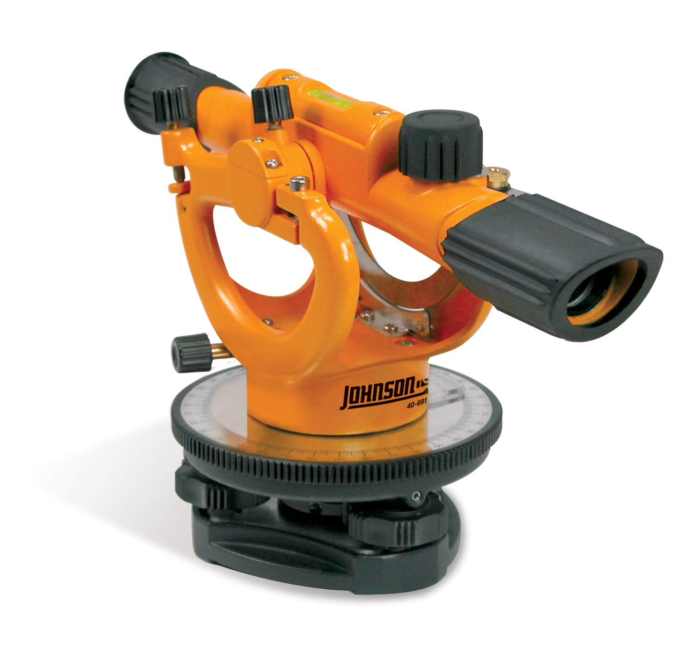
Traditional Surveying Tools
Before technology took over, land surveyors used a variety of traditional tools. These tools are still valuable today, especially in remote areas where advanced technology might not be available. Here are some of the key traditional tools:
- Measuring Tape: Simple and effective. It’s used for short distances.
- Leveling Rod: This rod helps measure the height difference between two points.
- Plumb Bob: A weight with a pointed tip on the bottom. It ensures that the tool is vertical.
- Compass: Helps in determining the direction. Useful for mapping and navigation.
These tools require skill and patience. Surveyors often need to work in pairs to get accurate readings. For instance, one might hold the leveling rod while the other looks through the transit to take readings. My uncle, who was a land surveyor, always said, “A steady hand and a keen eye are your best friends.”
Modern Technological Instruments
Today, technology has made measuring land elevation changes easier and more accurate. Here are some modern instruments you might find useful:
- GPS Devices: These provide precise location data. They can measure elevation changes over large areas.
- Total Stations: A combination of an electronic theodolite and an electronic distance meter. It measures angles and distances.
- LiDAR: Uses laser light to measure distances. It creates detailed 3D maps of the terrain.
- Drones: Equipped with cameras and sensors. They offer a bird’s eye view and can cover large areas quickly.
These modern tools are not only accurate but also save a lot of time. For example, using a drone, you can survey a large piece of land in a fraction of the time it would take using traditional methods. Plus, you get high-resolution images and data that can be analyzed later.
In conclusion, whether you use traditional tools or modern instruments, the key is to understand how they work and use them effectively. Both have their place in land surveying, and sometimes, a combination of both is the best approach.

Credit: www.wikihow.com
Methods For Measuring Elevation
Understanding land elevation changes is crucial for various applications. These include construction, agriculture, and environmental monitoring. Accurate measurements help in planning and decision-making. Different methods are available to measure elevation changes. This section explores two popular methods.
Gps And Satellite Methods
GPS and satellites offer precise elevation data. They use signals from multiple satellites. These signals help in triangulating exact positions. GPS devices are portable and easy to use. They provide accurate and real-time elevation data. Satellites such as the European Space Agency’s Sentinel-1 also assist. They monitor large areas and deliver consistent data. This method is reliable for large-scale projects. It is especially useful in remote areas. No physical markers are needed on the ground. The technology is constantly improving, increasing accuracy.
Laser Scanning Techniques
Laser scanning, also known as LiDAR, is another method. It stands for Light Detection and Ranging. This technique uses laser beams to measure distances. The laser beams bounce back from the ground. The time taken for the light to return is recorded. This data is then used to calculate elevation. LiDAR is very precise and can map detailed terrain. It is effective for both small and large areas. Drones and aircraft often carry LiDAR sensors. They can cover large areas quickly. This technique is ideal for creating detailed topographic maps. It is also used in forestry, urban planning, and archaeology.
Field Survey Procedures
Hey there! Today, we’re diving into a super interesting topic: how to measure and calculate land elevation changes. Specifically, we’ll be looking at Field Survey Procedures. It’s simpler than you might think! We’ll break it down step by step so you can get a clear understanding. Ready? Let’s jump in!
Planning The Survey
First things first, you need to plan your survey. Think of it like planning a road trip. You wouldn’t just hop in the car and start driving, right? You’d need a map, a destination, and a plan for stops along the way.
Here are some steps to help you plan:
- Identify the area: Know exactly where you need to measure.
- Gather tools: You’ll need a few basic tools like a GPS device, a leveling instrument, and a measuring tape.
- Set goals: What do you want to achieve with this survey? Knowing your goals will help guide your process.
Conducting Field Measurements
Now that you have a plan, it’s time to get out there and start measuring. This is the fun part! Imagine you’re a detective gathering clues.
Follow these steps:
- Set up your equipment: Place your leveling instrument on a tripod and make sure it’s stable.
- Take initial readings: Use your GPS device to get initial elevation readings at key points.
- Measure distances: Use your measuring tape to measure distances between points. This helps in calculating changes accurately.
- Record data: Write down your readings and measurements. Keeping a detailed log is crucial.
One tip from my own experience: double-check your measurements. It’s easy to make a small mistake that can throw off your entire survey. Better safe than sorry!
And there you have it! With these simple steps, you’re well on your way to successfully measuring and calculating land elevation changes. It’s not rocket science, but it does require careful attention to detail. Happy surveying!
Data Analysis Techniques
Hey there! If you’re curious about how land elevation changes are measured and calculated, you’re in the right place. In this section, we’ll dive into Data Analysis Techniques. We’ll break it down into simple steps so you can understand how experts interpret raw data and use software for analysis. Let’s get started!
Interpreting Raw Data
First things first, you need to know what raw data is. Imagine you’re baking a cake. Raw data is like your ingredients – flour, sugar, eggs. It’s the basic stuff. In land elevation, raw data can include:
- GPS readings
- Satellite images
- Surveyor notes
These data points need to be collected carefully. Think of it like making sure you have fresh eggs for your cake. Once you have your raw data, it’s time to interpret it.
You look at the numbers and figures. What do they tell you? Maybe the elevation has changed due to erosion. Or perhaps there’s been a landslide. The goal is to understand what the data says about the land.
Using Software For Analysis
Now, let’s talk about using software for analysis. Imagine trying to solve a puzzle. The software is like the picture on the puzzle box. It helps you see the big picture.
There are many types of software that can help. Some popular ones include:
- ArcGIS
- QGIS
- AutoCAD
These tools can help you analyze the data more accurately. They make it easy to create maps and models of the land. You can see exactly how the elevation has changed over time.
Using software is like using a calculator for math. It makes the work faster and more precise. Plus, it’s easier to share your findings with others.
So, there you have it! Understanding Data Analysis Techniques is crucial for measuring and calculating land elevation changes. By interpreting raw data and using the right software, you can get a clear picture of what’s happening with the land.
Have questions or tips to share? Feel free to leave a comment below. Happy analyzing!
Calculating Elevation Changes
Hey there! Today, we’re diving into a topic that might seem tricky at first but is super important if you’re working with land. We’re talking about calculating elevation changes. So, how do you measure how high or low the ground is? Let’s break it down into simple steps.
Mathematical Formulas
First up, let’s talk about the numbers. Don’t worry, you won’t need to be a math whiz to understand this. We use some basic formulas to measure elevation changes. It’s like using a recipe to bake a cake. You just need to follow the steps.
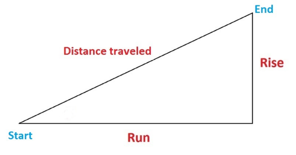
- Elevation Difference: This is the difference between two points. Imagine you’re hiking up a hill. You start at the bottom (Point A) and climb to the top (Point B). The elevation difference is simply how much higher Point B is compared to Point A.
- Slope Calculation: To find out how steep the hill is, you can use the slope formula. It’s like figuring out how steep a slide is before you go down. The formula is:
Slope = (Change in Elevation) / (Distance)
These formulas help you understand how much the land goes up or down and how steep it is.
Case Studies And Examples
Now, let’s look at some real-life examples. Imagine you’re a farmer, and you need to know if your field is sloping. Why? Because water flows downhill, and you want to make sure your crops get the right amount of water.
- Example 1: A farmer measures the elevation at two points in his field. Point A is 100 meters, and Point B is 110 meters. The elevation change is 10 meters. If the distance between these points is 50 meters, the slope is
10/50 = 0.2or 20%. - Example 2: A city planner wants to build a road. They measure the elevation at two ends. Point A is 50 meters, and Point B is 70 meters. The elevation change is 20 meters. If the distance between these points is 100 meters, the slope is
20/100 = 0.2or 20%.
These examples show how easy it can be to measure and calculate elevation changes. It’s like following a simple recipe. Just measure, plug in the numbers, and you’re good to go!
So next time you need to figure out how high or low your land is, just remember these easy steps. With a little practice, you’ll be calculating elevation changes like a pro!
Challenges And Solutions
Measuring and calculating land elevation changes can be challenging. Various factors can affect accuracy. Knowing these challenges and finding solutions is vital.
Common Measurement Errors
Errors often occur during the measurement process. Human error is a frequent issue. Misreading instruments or incorrect data entry can lead to mistakes.
Environmental factors also play a role. Weather conditions like rain or fog can affect the accuracy of measurements. Uneven ground or obstacles can cause additional errors.
Overcoming Technical Difficulties
Technical difficulties can hinder accurate measurements. Equipment malfunction is a common problem. Regular maintenance and calibration of instruments can help.
Using advanced technology can provide more reliable results. GPS devices and drones offer higher accuracy. They can also cover larger areas with less effort.
Training is essential for those using these tools. Proper training ensures correct use and accurate data collection.
Future Trends In Elevation Measurement
Hey friends, today we’re diving into the future of measuring land elevation changes. It’s an exciting topic, especially with all the new tech coming our way. Imagine how accurate and easy it will be to measure the heights and dips of the land around us. Let’s explore what lies ahead!
Emerging Technologies
New technologies are making it easier to measure elevation changes. These tools are more accurate and user-friendly. Here are a few emerging technologies:
- LiDAR: This technology uses lasers to measure distances. It’s very precise and can create detailed maps.
- GPS: Yes, the same system that helps you find your way. Advanced GPS can measure elevation changes accurately.
- Drones: These flying gadgets can carry cameras and sensors to map out land elevation from above.
Potential Innovations
What’s next in the world of elevation measurement? Let’s peek into the potential innovations:
- AI and Machine Learning: Imagine software that learns and gets better at predicting changes in elevation. This could make our measurements even more accurate.
- Wearable Tech: Think smartwatches but for land surveyors. These could make it easier to gather data on the go.
- Virtual Reality (VR): VR could help us visualize elevation changes in a 3D environment. This could be useful for planning construction or environmental projects.
The future of elevation measurement looks bright. With these emerging technologies and potential innovations, we’ll be able to measure land changes more accurately and easily than ever before. It’s like having a crystal ball for our planet’s surface! Stay tuned for more exciting updates in the world of land elevation measurement.
Credit: www.johnsonlevel.com
Frequently Asked Questions
How To Calculate Elevation Change?
To calculate elevation change, subtract the starting elevation from the ending elevation. Use a GPS device or topographic map for accuracy.
How Do You Measure Elevation Change In A Yard?
Use a line level, measuring tape, and stakes. Measure the yard’s length and height difference. Calculate elevation change by dividing height by length.
How Do You Calculate Land Elevation?
Calculate land elevation using GPS devices, altimeters, or topographic maps. Surveying equipment like theodolites also helps.
How Do Surveyors Measure Elevation?
Surveyors measure elevation using tools like theodolites, total stations, and GPS. They calculate height differences between points.
Conclusion
Measuring land elevation changes is simpler than it seems. With the right tools, anyone can do it. GPS devices, digital levels, and online tools help a lot. Regular monitoring helps detect changes early. This can prevent potential issues. Practice these methods and ensure your land remains stable.
Understanding elevation changes is crucial for safety and planning. Keep learning and stay informed. Your land will thank you.