

Drones are changing the way we survey in construction and engineering. They offer new possibilities for accuracy and efficiency.
The future of drone surveying is bright. In the coming years, drones will become an essential tool in these fields. They can quickly capture detailed data from above. This helps in planning and monitoring projects better. Drones reduce the need for manual labor and lower costs.
They are also safer, as they can access hard-to-reach areas. With advances in technology, drones will provide even more precise and useful information. This will lead to better decision-making and project outcomes. Stay tuned to learn more about how drones will shape the future of construction and engineering.
Introduction To Drone Surveying
Hey friends, today we’re going to explore something super exciting. Have you ever wondered how drones are changing the construction and engineering world? Well, let me introduce you to the fascinating world of drone surveying. It’s a game-changer. Let’s dive in!
Emergence Of Drone Technology
First, let’s talk about how drones came into the picture. Drones, also known as UAVs (Unmanned Aerial Vehicles), started as tools for the military. But now? They’re everywhere. From delivering packages to capturing stunning aerial photos. And now, in construction and engineering. They help us see things from the sky that we couldn’t before.
Importance In Construction And Engineering
So, why are drones so important in construction and engineering? Let’s break it down:
- Accuracy: Drones can take highly accurate measurements. This means fewer mistakes.
- Safety: No need to climb dangerous heights. The drone does it for you.
- Time-Saving: Traditional surveys take time. Drones are quick. They can survey large areas in minutes.
- Cost-Effective: Less time means less money spent. Simple as that.
Imagine you’re building a new skyscraper. You need to know every detail of the land. In the past, this would take weeks. Now, with drones, it takes just a few days. And the data? Crystal clear.
Here’s a quick table to show you the difference:
| Traditional Surveying | Drone Surveying |
|---|---|
| Weeks to complete | Days to complete |
| High risk for workers | Low risk for workers |
| Expensive | Cost-effective |
| Less accurate | Highly accurate |
Pretty cool, right? Drones are making everything easier and safer. Next time you see a construction site, look up. You might just spot a drone at work!
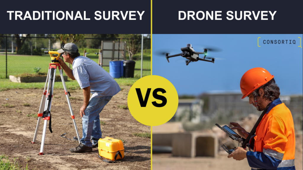
Credit: consortiq.com
Advantages Of Drone Surveying
Hey there! Today, we’re going to dive into something super cool – drone surveying. You might wonder why it’s gaining so much attention in construction and engineering. Well, it offers a lot of advantages. Let’s explore them one by one.
Increased Accuracy
First off, drones are like the eagle-eyed watchers from above. They capture detailed images and data with incredible precision. This means fewer errors compared to traditional methods. Think about it – when building a house or a bridge, every millimeter counts. Drone surveying ensures everything is spot on.
- Better measurements
- Accurate mapping
- High-quality images
Time And Cost Efficiency
Now, let’s talk about saving time and money. Drone surveying is fast. Really fast. It can cover large areas in no time. This means projects move along quicker. And quicker projects? They cost less. Simple as that.
Here’s a quick comparison:
| Traditional Surveying | Drone Surveying |
|---|---|
| Days or weeks | Hours |
| High labor costs | Lower labor costs |
So, drones are a win-win. Faster surveys and lower costs. Imagine finishing a survey in hours instead of days. You’d have more time for other important tasks, right?
That’s just a glimpse into the advantages of drone surveying. It’s accurate and efficient. And most importantly, it makes your job easier. Stay tuned for more exciting insights on how drones are shaping the future of construction and engineering!
Technological Innovations
Drone surveying is changing the way construction and engineering projects are done. The use of drones helps in getting accurate data quickly. But what makes drone surveying even more exciting? The latest technological innovations. These innovations are making drones more powerful and smarter. Let’s take a look at some key areas:
Advanced Imaging Technologies
One of the coolest things about modern drones is their imaging capabilities. Gone are the days when blurry photos were the best you could get. Today, drones come with high-resolution cameras that capture clear and detailed images. But that’s not all. Drones can now use thermal imaging and LiDAR technology.
- Thermal Imaging: This helps in detecting heat patterns. It is useful for finding problems in buildings, like leaks.
- LiDAR: This stands for Light Detection and Ranging. It uses lasers to create 3D maps. These maps are super accurate and help in planning construction projects.
Integration With Ai And Machine Learning
Another fascinating area is the integration of Artificial Intelligence (AI) and Machine Learning (ML) with drones. AI and ML make drones smarter. They can analyze data faster and more accurately. Imagine a drone that can not only take pictures but also tell you what those pictures mean.
This is how AI and ML are enhancing drone surveying:
- Data Analysis: Drones can now analyze the data they collect. This helps in making quick decisions on the construction site.
- Predictive Maintenance: AI can predict when a machine or part will fail. This helps in fixing problems before they become big issues.
My friend Joe works in construction. He recently used a drone with AI to inspect a large building. The drone not only took pictures but also found cracks in the walls. Joe was amazed at how much time and effort it saved him.
In conclusion, technological innovations are taking drone surveying to the next level. From advanced imaging technologies to AI and ML, these advancements are making construction and engineering projects more efficient and accurate. The future of drone surveying looks bright, and these technologies will play a big part in it.
Applications In Construction
The future of drone surveying in construction and engineering is bright. Drones have various applications in construction. They help improve efficiency and accuracy. Their advanced capabilities transform how projects are managed.
Site Analysis And Planning
Drones quickly capture detailed site data. This data helps in planning and decision-making. They provide high-resolution images and 3D models. These models help engineers understand the site’s topography. They can identify potential issues early. This saves time and resources.
Drone surveys are faster than traditional methods. They cover large areas in less time. This speeds up the planning process. Engineers can access real-time data. This data helps in creating accurate plans. It ensures that projects are on track from the start.
Progress Monitoring
Drones play a crucial role in progress monitoring. They provide regular updates on construction sites. This helps project managers track progress. They can identify any delays or issues quickly. This allows for timely interventions.
High-quality images and videos offer a clear view of the site. Managers can compare these with project timelines. This ensures that the project stays on schedule. Drones also help in documenting the work done. This is useful for reporting and future reference.
Using drones for progress monitoring improves communication. Stakeholders can easily access visual updates. This transparency fosters trust and collaboration. Drones are changing how construction projects are managed. They offer a practical solution for efficient progress monitoring.
Applications In Engineering
Drones are transforming the landscape of engineering. They offer new ways to survey and inspect. Their applications are vast and varied. From infrastructure inspection to environmental impact assessments, drones provide valuable data and insights.
Infrastructure Inspection
Engineers need to inspect infrastructure regularly. Drones make this process faster and safer. They can fly over bridges, buildings, and roads. They capture high-resolution images and videos. These visuals help identify cracks, wear, and other issues.
Drones can access hard-to-reach areas. This reduces the need for scaffolding or ladders. Engineers analyze the captured data to plan maintenance. This proactive approach saves time and money.
Environmental Impact Assessments
Environmental assessments are crucial in construction. Drones simplify this task. They survey large areas quickly. They capture detailed images of the terrain. These images help identify sensitive zones.
Drones also monitor changes over time. This helps track the impact of construction on the environment. Engineers use this data to minimize damage. They plan projects that are eco-friendly. Drones make it easier to protect the environment.

Credit: www.linkedin.com
Challenges And Limitations
Hey friends, today we’re diving into the challenges and limitations of drone surveying in construction and engineering. While drones have become incredibly useful, they come with their own set of hurdles. Let’s break these down into two main categories.
Regulatory Hurdles
First up, the rules. Governments have laws about where and when you can fly drones. For example, you can’t fly near airports. You also need special permits for certain areas. And yes, these rules change from country to country. This means more paperwork and planning. Sometimes, the red tape can slow down projects.
- Permits: You might need a special permit to fly.
- Restricted Areas: Places like airports have no-fly zones.
- Changing Laws: Drone laws can change, adding more complexity.
I recently asked a friend who works in construction about this. He said, “It’s like having to ask for permission every time you want to use your new tool.”
Technical Limitations
Next, let’s talk tech. Drones are awesome, but they aren’t perfect. For starters, battery life is short. You might get 30 minutes of flight time. That’s it. Then, there are weather issues. Rain and strong winds? Not good for drones. And don’t forget about data storage. High-resolution images take up a lot of space.
- Battery Life: Limited to about 30 minutes.
- Weather: Rain and wind can ground your drone.
- Data Storage: High-res images need lots of space.
Here’s a quick story. I was once helping on a small construction site. We planned to use a drone for a survey. Guess what? It started raining. We had to wait for hours. Frustrating, right?
So, there you have it. Regulatory hurdles and technical limitations are two major challenges in drone surveying. But don’t worry, with careful planning and a bit of patience, these can be managed. Until next time, keep exploring and learning!
Future Trends In Drone Surveying
The future of drone surveying in construction and engineering looks bright. As technology advances, new trends are emerging. These trends promise to enhance efficiency and accuracy. Drones are becoming a critical tool in the industry. Let’s explore some of these future trends.
Autonomous Drones
Autonomous drones are becoming more common. They can operate without human intervention. This means they can perform tasks faster. They can also work in challenging environments. This reduces risks for human workers. Autonomous drones can be pre-programmed to follow specific routes. This ensures consistent and accurate data collection. They can also adapt to changes in the environment. This makes them highly reliable tools.
Enhanced Data Processing
Data processing is crucial in drone surveying. Enhanced data processing methods are emerging. These methods use advanced algorithms. They can process large amounts of data quickly. This results in more detailed and accurate maps. Enhanced data processing also enables real-time analysis. This allows engineers to make quick decisions. Improved software tools are making this possible. These tools are user-friendly and efficient.

Credit: appinventiv.com
Case Studies And Success Stories
Hey friends, today we’re diving into something really exciting – the future of drone surveying in construction and engineering. And guess what? We’ll be looking at some amazing case studies and success stories that showcase just how impactful this technology has been. Ready to be inspired? Let’s go!
Notable Projects
One of the coolest projects I’ve come across is the construction of the new stadium in Tokyo. Drones were used to map the entire site with pinpoint accuracy. The good news? This saved tons of time and reduced costs significantly. Imagine trying to do all that manually. It would take forever!
Another great example is the highway expansion in Texas. Drones provided real-time data, helping engineers make quick decisions. This meant fewer delays and a smoother project overall. The results? A faster, more efficient build and happier commuters.
Lessons Learned
So, what can we learn from these projects? A lot, actually. Here are some key takeaways:
- Accuracy is everything: Using drones ensures precise measurements and data, which is crucial for any construction or engineering project.
- Time is money: Drones can survey large areas quickly, saving valuable time and reducing labor costs.
- Safety first: Drones can access dangerous or hard-to-reach areas, keeping workers safe and minimizing risks.
And the best part? These benefits apply to projects of all sizes, from small residential builds to massive infrastructure developments.
I recently asked a friend who works in construction about their experience with drones. They said, “Using drones has been a game-changer for us. It’s like having an extra set of eyes in the sky. We can spot issues before they become problems.”
The future of drone surveying in construction and engineering looks bright. With more innovative projects on the horizon, there’s no limit to what we can achieve. So, if you’re in the industry, now’s the time to explore how drones can help you. The results might just surprise you!
Frequently Asked Questions
What Is The Future Of Drones In Construction?
Drones will revolutionize construction by enhancing site surveys, monitoring progress, and improving safety. They provide real-time data, increasing efficiency.
How Are Drones Changing The Construction Industry?
Drones are revolutionizing construction by enhancing site surveys, improving safety, and boosting efficiency. They provide precise data, aerial imagery, and real-time monitoring.
How Are Drones Used In Construction And Engineering?
Drones in construction and engineering perform site surveys, monitor progress, inspect structures, and create 3D models. They enhance safety, efficiency, and data accuracy.
How Much Do Drone Surveyors Make?
Drone surveyors typically earn between $50,000 and $70,000 per year. Experience and location can influence salaries.
Conclusion
Drone surveying promises a bright future for construction and engineering. It offers speed, accuracy, and cost savings. These benefits are reshaping the industry standards. Companies adopting drone technology stay competitive. Drones also improve safety by reducing human risk. Expect wider use of drones in upcoming projects.
They will soon become essential tools. Embrace this technology for better project outcomes. The future of drone surveying looks promising and impactful.