

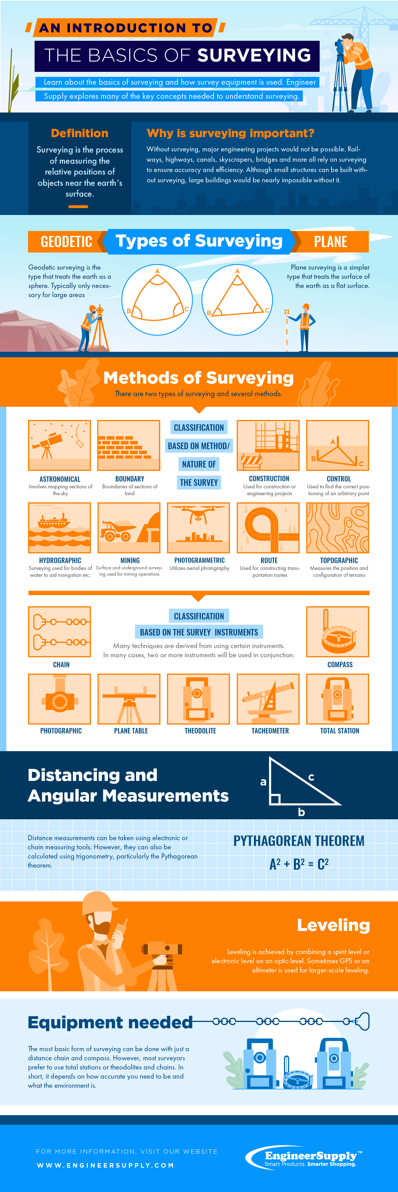
Topographic surveying is essential for construction projects. It provides detailed land measurements.
Understanding topographic surveying is crucial for successful construction. It helps in planning, design, and execution. This process involves mapping the land’s surface, identifying features, and noting elevations. By using precise instruments, surveyors create accurate maps. These maps guide architects, engineers, and builders.
They ensure structures are built correctly and safely. Topographic surveys identify potential issues early, saving time and money. They are the backbone of any construction project. This introduction will explore the basics of topographic surveying. Discover its importance and how it supports construction success.
Introduction To Topographic Surveying
Topographic surveying is a vital process in construction projects. It involves measuring the elevation of points on a piece of land. This helps create a detailed map of the area. Builders use this map to understand the terrain better. It guides them in planning and designing structures.
Importance In Construction
Topographic surveys help identify land features. This includes hills, valleys, and flat areas. Knowing these features aids in making informed decisions. Builders can avoid problem areas. It helps in preventing costly mistakes.
These surveys also determine the best locations for buildings. It ensures structures are built on stable ground. This enhances safety and durability. Accurate topographic data can lead to better project outcomes.
Key Objectives
The main goal is to gather detailed data about the land. This data includes elevations and natural features. It also records man-made structures. Surveyors use specialized equipment for accuracy. They create maps that show all critical details.
Another objective is to help in planning. Survey results guide the design and layout of buildings. It ensures the project fits well with the land. Proper planning reduces risks and improves efficiency.
Topographic surveys also assist in managing resources. They help in the efficient use of materials. It can lead to cost savings. They ensure the construction process runs smoothly.

Credit: dudek.com
Essential Tools And Equipment
Hey friends, today we’ll dive into the essential tools and equipment used in topographic surveying for construction projects. Whether you’re just starting out or refreshing your knowledge, understanding these tools is key. Let’s get into it!
Surveying Instruments
First up, we have the surveying instruments. These are the backbone of any topographic survey. They help you measure distances, angles, and elevations accurately. Think of them as your trusty sidekicks.
- Theodolites: These instruments measure horizontal and vertical angles. They are highly precise.
- Total Stations: Combining theodolites and electronic distance measurement, these are more advanced and versatile.
- Levels: These are used to measure height differences. They come in handy for construction site leveling.
- GPS Units: These provide location data and are essential for mapping and positioning.
Software And Technology
Next, let’s talk about software and technology. In today’s digital age, they play a huge role in surveying. They make the process smoother and more efficient.
Here are some common tools you’ll encounter:
- CAD Software: CAD stands for Computer-Aided Design. This software helps create detailed maps and plans.
- GIS Software: Geographic Information System software is used to analyze and visualize spatial data.
- Data Collectors: These devices store the data collected in the field. They can be handheld or part of the surveying instrument.
- Drone Technology: Drones are becoming increasingly popular for capturing aerial images and data.
The good news? You don’t need to master all these tools at once. Start with the basics and build your way up.
Remember, the right tools make a big difference. So, get familiar with them, and you’ll be on your way to successful surveying in no time.
Surveying Techniques
Surveying techniques are vital for accurate topographic surveying in construction projects. These techniques provide precise measurements and data to map the land’s surface. Understanding the different methods used in surveying can help ensure successful project outcomes.
Traditional Methods
Traditional surveying methods include tools like theodolites and levels. Theodolites measure horizontal and vertical angles. Levels measure elevation differences. These instruments require manual operation and skilled surveyors. Manual plotting on paper maps is also part of traditional methods. This process can be time-consuming but provides reliable results.
Modern Approaches
Modern surveying approaches use advanced technology for faster and more accurate results. Total stations combine theodolites and electronic distance measurement. This technology automates data collection and calculations. GPS surveying is another modern approach. It uses satellites to determine precise locations on the earth’s surface. Drones are also used for aerial surveys. They capture high-resolution images and create detailed 3D models of the terrain. These modern techniques save time and improve accuracy.
Data Collection Process
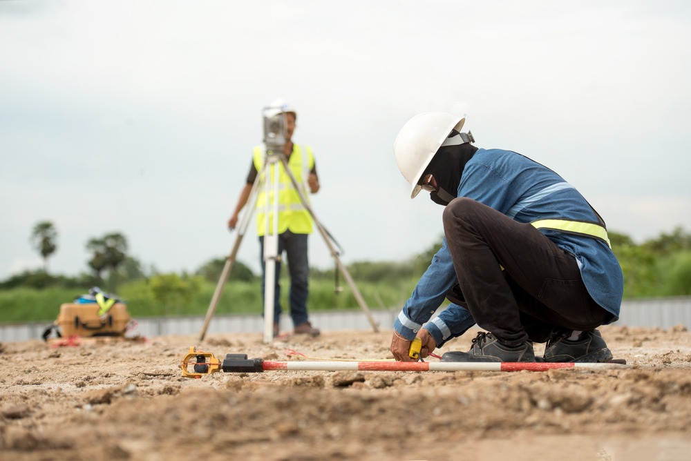
The data collection process is crucial in topographic surveying for construction projects. It ensures accurate mapping of the land surface. This helps in planning and executing construction activities.
Field Procedures
Surveyors start by visiting the site. They set up their equipment, such as theodolites and GPS units. These tools measure angles, distances, and elevations. Surveyors move across the site, taking numerous measurements. This step is vital for capturing the land’s features accurately.
Data Recording
Surveyors record measurements in field books or digital devices. Accuracy is key during this stage. Errors can lead to incorrect data, affecting the project. Surveyors often double-check their entries to ensure precision. They also note any significant features like trees, buildings, or water bodies.
Once the data is collected, it is transferred to a computer. Specialized software processes this information. The result is a detailed map of the surveyed area. This map is then used by engineers and architects for planning.
Data Analysis And Interpretation
Hey friends, today we’re diving into the world of topographic surveying for construction projects. One key part of this process is Data Analysis and Interpretation. This step is crucial because it helps us understand the land’s shape and features. Let’s break it down into easy steps: processing survey data and creating topographic maps.
Processing Survey Data
First, we need to process the data collected during the survey. Think of it like baking a cake. You have all the ingredients, but you need to mix them correctly to get a tasty result. Here’s how we do it:
- Collect Data: Surveyors gather information using tools like GPS and total stations. This data includes points on the land, elevations, and other features.
- Organize Data: Once collected, the data is organized into a computer program. This helps us see patterns and make sense of the information.
- Clean Data: Sometimes, data can have errors. We need to fix these errors to ensure our analysis is accurate. This step is like removing the eggshells from your cake batter.
By processing the survey data correctly, we ensure that the information we use is reliable and accurate.
Creating Topographic Maps
After processing the data, the next step is creating topographic maps. These maps are like the final cake, showing the land’s shape and features in a clear way. Here’s how we create them:
- Input Data: The cleaned data is input into mapping software. This software helps us visualize the land’s surface.
- Generate Contours: The software creates contour lines. These lines show different elevations on the map, kind of like how a cake has different layers.
- Add Details: We add details like trees, buildings, and roads. This makes the map more useful for construction projects.
Creating a topographic map is like decorating your cake. You add the final touches to make it look good and be useful.
So, that’s it! The basics of data analysis and interpretation in topographic surveying. By processing survey data and creating topographic maps, we can understand the land better and plan our construction projects effectively.
I remember the first time I worked with survey data. It felt like solving a giant puzzle. But once I got the hang of it, it became a fun and rewarding task. Just like baking a cake, with practice, you’ll get better and better.
Credit: www.engineersupply.com
Common Challenges
Topographic surveying is crucial in construction projects. It provides detailed information about the land’s surface. But, several challenges can arise. Understanding these challenges helps in managing them effectively. This section discusses common challenges in topographic surveying.
Accuracy Issues
Accuracy is vital in topographic surveying. Even minor errors can lead to significant problems. Surveyors must use precise instruments. They must also follow strict procedures. Human error is a common issue. It can occur during data collection or processing. Equipment calibration is another concern. Instruments need regular calibration for accurate results. Software errors can also impact accuracy. Surveying software must be updated and checked regularly.
Environmental Factors
Environmental factors greatly affect topographic surveying. Weather conditions can pose challenges. Rain, snow, and fog can obstruct visibility. This makes data collection difficult. Extreme temperatures can affect equipment performance. Surveyors must work in all conditions. Terrain is another challenge. Steep slopes and uneven ground can be hard to navigate. Vegetation can also obstruct survey lines. Thick forests or dense bushes can limit access to certain areas.
Applications In Construction
Hey friends, today we are diving into a key topic in construction: The Basics of Topographic Surveying for Construction Projects. We’re focusing on how these surveys are used in construction. Topographic surveys are like the building blocks for construction. They help you understand the land. Let’s see how they are applied in real projects.
Site Planning
First up, we have site planning. Imagine you want to build a house. You need to know where everything should go. This is where topographic surveys come in handy. They give you a map of the land. This map shows the land’s shape, like hills and valleys.
- Identify the best place for buildings
- Plan roads and pathways
- Locate natural resources like water bodies
For example, when I was helping my friend build a small cabin, we used a topographic survey. It showed us where the ground was flat. We knew where to place the cabin. Simple, right?
Infrastructure Development
Next, let’s talk about infrastructure development. This is about building the stuff we use every day. Roads, bridges, and pipelines. These projects need careful planning. Why? Because they need to fit the land perfectly.
Here’s how topographic surveys help:
- Designing roads: Engineers use the land’s shape to create safe and smooth roads.
- Planning drainage systems: Surveys show where water flows, so we can avoid flooding.
- Building bridges: Knowing the land’s shape ensures the bridge is stable and secure.
Take the example of building a highway. Engineers need to know where the land is high or low. This helps them design a road that is safe and cost-effective. They use the survey to decide where to cut through hills or where to build up the land.
In short, topographic surveys are essential in construction. They help us plan and build better. Whether it’s a small cabin or a major highway, these surveys make it all possible. So, the next time you see a new building or road, remember the topographic survey that helped make it happen.
Future Trends
The future of topographic surveying in construction is evolving rapidly. New trends are reshaping the industry, ensuring more efficient and sustainable practices. These advancements promise to improve accuracy, reduce costs, and minimize environmental impact.
Technological Advancements
Technological advancements in topographic surveying are driving changes in the industry. Drones equipped with high-resolution cameras provide detailed aerial views. These views help create accurate topographic maps quickly. The use of LiDAR technology is also on the rise. LiDAR captures precise measurements, even in challenging terrains. This technology allows surveyors to work more efficiently and safely.
Sustainable Practices
Sustainable practices are becoming crucial in topographic surveying. The construction industry aims to reduce its environmental footprint. Surveyors now use eco-friendly materials and methods. Digital data collection reduces the need for paper. Renewable energy sources power some surveying equipment. These practices contribute to a greener construction process.
Credit: mjslandsurvey.com
Frequently Asked Questions
What Is A Topographic Survey In Construction?
A topographic survey in construction maps the land’s contours, elevations, and features. It aids in site planning and design.
How To Start A Topographic Survey?
Begin a topographic survey by gathering necessary equipment and maps. Visit the site to assess terrain features. Use GPS or total stations to collect data. Record elevations, contours, and significant landmarks. Compile data into detailed maps and reports.
What Are The Methods Of Topographic Surveying?
Topographic surveying methods include ground survey, aerial survey, and satellite survey. Ground surveys use traditional tools like theodolites and GPS. Aerial surveys employ drones and airplanes. Satellite surveys utilize remote sensing technology. Each method serves specific needs based on accuracy, cost, and terrain.
What Is The Principle Of Topographic Survey?
A topographic survey measures the elevation of points on a piece of land and presents them as contour lines on a map.
Conclusion
Topographic surveying is crucial for successful construction projects. It provides essential data. Understanding the basics helps in making informed decisions. Accurate surveys ensure proper planning and execution. They reduce risks and unexpected costs. Construction teams rely on these surveys for precise measurements.
Knowing topographic details can save time and resources. It’s a vital step for any construction project. With this knowledge, you can confidently move forward. Embrace the importance of topographic surveying in your projects. It’s a fundamental aspect that ensures smooth project progression.